PulsePoint Respond
Responder Types and Features
PulsePoint Respond offers three responder types—Public CPR Responder, Registered CPR Responder, and Professional Responder. PulsePoint AED offers AED-Needed Responder. Deploying a combination of these responder types can maximize PulsePoint's community impact. The responder types are detailed below, followed by a feature matrix to help illustrate the differences.


Public CPR Responder

Public CPR Responders are typically community members trained in CPR and automated external defibrillator (AED) use and willing to assist if an incident occurs near them. These community first responders are only notified of nearby cardiac arrest events occurring in public places. To promote daily app usefulness and encourage program participation, these users are shown a filtered list of emergencies occurring in the community and offered notifications of public interest events such as traffic collisions and wildland fires.
Registered CPR Responder

Registered CPR Responders are agency-invited members of the community with medical or rescue training, such as public safety retirees, CERT members, medical professionals, and residential security staff or residents with special neighborhood responsibilities. These community responders are alerted to all nearby cardiac arrest events, including private residences. With nearly 70% of cardiac arrest events occurring in the home, this difference is significant. Like Public CPR Responders, these users are shown a filtered list of emergencies occurring in the community.
Professional Responder

Professional Responders are active public safety employees, typically firefighters, paramedics, and law enforcement officers assigned Professional Responder status by their organization. Typically these employees respond and care for patients in residential settings while on duty. To encourage adoption, professional users are provided with specialized app capabilities for on-duty use. When off-duty, Professional Responders are alerted to all nearby cardiac arrest events in the jurisdiction.
AED
Responder

AED-Needed Responders are community members that own an AED or have immediate access to an AED—such as an employee, neighbor or AED response program member. When a cardiac arrest occurs near their device, they receive an AED-Needed Alert requesting they bring the AED to the reported location. Multiple responders can subscribe to receive alerts for the same AED. These alerts are requested and received in the PulsePoint AED app and support all AED manufacturers and models.
PulsePoint Respond
App Features by Responder Type
| Public CPR Responder | Registered CPR Responder | Professional Responder | |
| User management | Self-managed | Agency-managed | Agency-managed |
| Nearby CPR-needed alerts | Public locations | All locations | All locations |
| Public interest alerts | Yes | Yes | Yes |
| Incident display | Filtered | Filtered | All |
| Expanded incident details | No | No | Yes |
| Instant navigation | Non-medical incidents | Non-medical incidents | All incidents |
| Destination View | CPR-needed | CPR-needed | All incidents |
| Assignment-based dispatch notifications | No | No | Yes |
| Saved incidents | No | No | Yes |
| AED map layer | Yes | Yes | Yes |
| Station map layer | Yes | Yes | Yes |
| Hydrant map layer | No | No | Yes |
| Preplan map layer | No | No | Yes |
| Unit location map layer | No | No | Yes |
| Traffic camera map layer | Yes | Yes | Yes |
| Wildfire camera map layer | No | No | Yes |
| Railroad crossing map layer | Yes | Yes | Yes |
| Incident narrative | No | No | Yes |
| Recent location history | No | No | Yes |
| Digital ID badge | No | No | Yes |
| AEDs and colocated resources | Recommend/comment | Recommend/comment | Approve/manage |
The legacy (public only) version of PulsePoint Respond does not include Registered CPR Responder and Professional Responder user types. Contact us for migration information.


User management
PUBLIC CPR RESPONDER
Public CPR Responders attest to CPR/AED training and self-manage enrollment within the app. This responder type requires no agency involvement other than encouraging participation and promoting program goals during community outreach opportunities. Public CPR Responders typically represent the greatest number of eligible responders in a community.
REGISTERED CPR RESPONDER
Registered CPR Responders are securely managed directly by the agency through PulsePoint Central.
PROFESSIONAL RESPONDER
Professional Responders (typically agency employees) are securely managed directly by the agency through PulsePoint Central.
| Public | Registered | Professional |
| Self-managed | Agency-managed | Agency-managed |
Nearby CPR-needed alerts
MOST CARDIAC ARREST EVENTS OCCUR IN THE HOME
Registered CPR Responders and Professional Responders receive nearby CPR-needed alerts for all locations, including private residences.
66,500 CARDIAC ARRESTS OCCURRED IN PUBLIC SETTINGS LAST YEAR (US)
Public CPR Responders receive nearby CPR-needed alerts where people gather, such as stores, gyms, restaurants and places of worship.
| Public | Registered | Professional |
| Public locations | All locations | All locations |


Public interest alerts
Improving situational awareness with PulsePoint can help build safer, stronger, and more resilient communities.
RISK AWARENESS
Public interest alerts allow all user levels to stay mindful of important incident activity that may be impactful. These informational notifications provide an early and automatic heads-up to local threats such as wildland fires, flooding and utility emergencies. Making the public aware of risks and helping them be prepared is an essential component of community risk reduction.
DAILY USEFULNESS IS KEY TO ENGAGEMENT
Users share the daily usefulness of PulsePoint with neighbors, family, and friends, and in turn, they help build and sustain a dynamic and reliable network of CPR-trained individuals.
| Public | Registered | Professional |
| Yes | Yes | Yes |
Incident display
THE VIEW UNFILTERED
Professional Responders are shown a traditional MDT/MDC-level display that includes all active and recent incidents, assigned resources/statuses, native call type descriptions, and complete address information.
COMMUNITY AWARENESS
Other user types see a filtered list of incidents with redacted details and location information for medical incidents. Agencies may choose to exclude medical incident types.
| Public | Registered | Professional |
| Filtered | Filtered | All |


Expanded incident details
KNOW THE WHOLE STORY
From a tap on the incident list, Professional Responders are provided additional details to improve their response capabilities and effectiveness. Available information varies between dispatch environments, but common data points include common place names, cross streets, radio channels, and incident narratives.
TURN TRAVEL TIME INTO STRATEGY TIME
The map thumbnail at the top of the details page opens to a full-screen, single-incident response map. This map displays map layers such as hydrants and preplans, real-time traffic conditions, and additional response aids such as destination view imagery. Since PulsePoint is an app, every crew member has access to this information—not just one seat.
| Public | Registered | Professional |
| No | No | Yes |
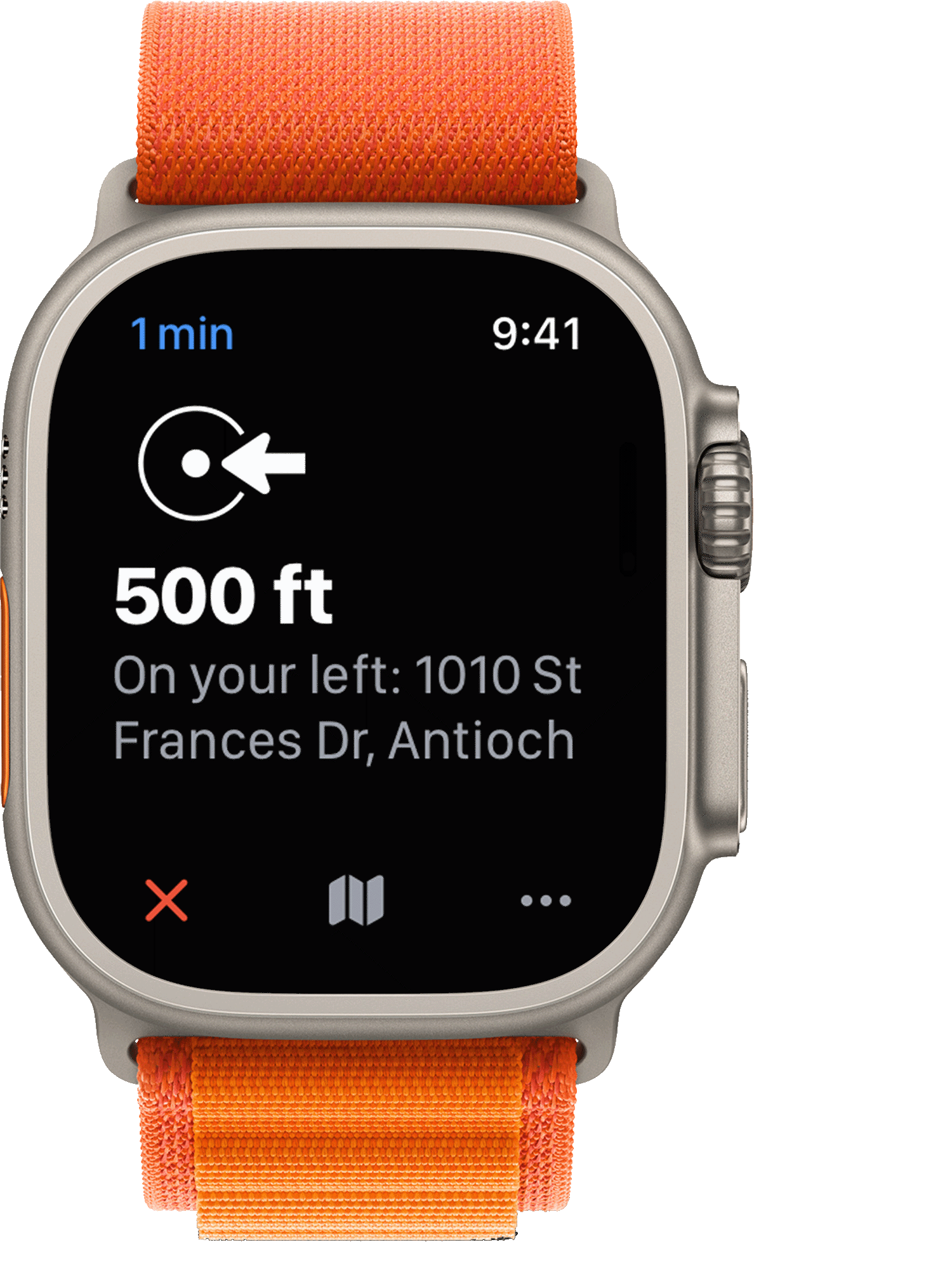
Instant Navigation
TURN-BY-TURN DIRECTIONS WITH LIVE TRAFFIC CONDITIONS
Professional Responders can receive immediate turn-by-turn driving directions to any incident by tapping the navigate icon on the incident detail thumbnail map. Other user types are not provided this functionality/icon on medical incident types.
| Public | Registered | Professional |
| Non-medical | Non-medical | All incidents |


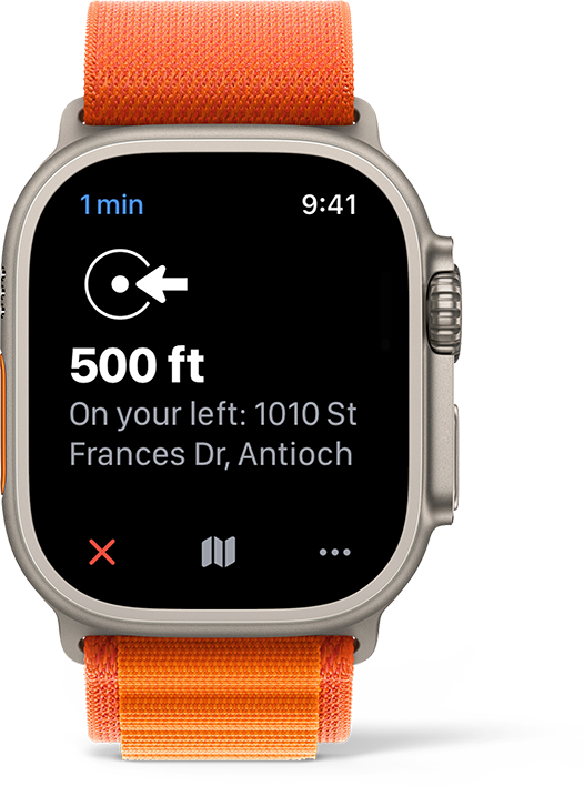


Destination View
GO THERE BEFORE YOU GET THERE
With Destination View professional users can view street-level imagery of where they're going before they arrive. Tap the Destination View thumbnail to view an interactive 360° daytime panorama of the destination address. The imagery can be panned, zoomed, and tilted to determine business or structure type, evaluate exposures, sight utility lines, identify access challenges and generally improve situational awareness while traveling to the scene.
| Public | Registered | Professional |
| CPR-needed | CPR-needed | All incidents |
Assignment-based dispatch notifications
NOTIFICATIONS FOR EVERY INCIDENT
Unit/Group notifications allow Professional Responders to receive dispatch notifications for all incidents based on assignment, such as station or apparatus (e.g., notify me of all incidents for Engine 35).
Agencies can define their notification groups to best meet organizational needs. View the adjacent images for common examples, including notifications by role, unit, or group of units.
Users can choose to receive Unit/Group notifications as a Critical Alert, a special type of notification that bypasses Do Not Disturb and mute settings, ensuring the notification is received, even if the phone is silenced or in Focus mode.
| Public | Registered | Professional |
| No | No | Yes |


Saved Incidents
FILED AWAY FOR FUTURE REFERENCE
Finishing a report or conducting follow-up on your next shift? Documenting an exposure from an incident? Drafting public information for a future release or briefing? You can bookmark an incident to retain access for up to 30 days.
ONE TAP, DONE
From the incident detail screen, tap the bookmark icon to save an incident. Access saved incidents by selecting the Saved feed from the incident list dropdown control. Remove a saved incident by tapping its bookmark icon again, or just let it expire.
| Public | Registered | Professional |
| No | No | Yes |
AED map layer
PROMOTE AND BUILD YOUR COMMUNITY REGISTRY
All user levels can view the AED map layer. Tapping an AED icon displays additional details including business/location name, AED location description, business open/closed status, and a contextual image of the AED, if available.
| Public | Registered | Professional |
| Yes | Yes | Yes |


Hydrant map layer
SECURE A SUPPLY
Firefighters can easily display the fire hydrant map layer when responding to incidents that may require a hydrant. Icon colors can be used to indicate expected hydrant performance or to meet other local standards. Tapping a hydrant icon displays additional hydrant characteristics, such as flow and outlet configuration, if available.
Tap Add Image to add a hydrant photo. Use the edit icon to replace or delete an image. Images collected during routine maintenance help responders in the field, such as previewing a hydrant while enroute to a fire, or locating a street valve when a sheared hydrant has flooded the surrounding area.
| Public | Registered | Professional |
| No | No | Yes |


Preplan map layer

KNOW THE PLAN
The preplan map layer makes existing preplan information instantly available to responding personnel. By default this layer also includes professionally developed CRG response plans created for schools, hospitals, and large-scale public events.
Purple preplan icons indicate the presence of a plan. Tap the icon to display the plan.
| Public | Registered | Professional |
| No | No | Yes |
Unit location map layer
AUTOMATIC VEHICLE LOCATION (AVL)
Agency personnel display the Units Map Layer to monitor the real-time location and activity of their fleet. Unit movement Information is typically acquired from a computer-aided dispatch (CAD) system interface or directly from vehicle-mounted GPS routers. In some cases, third-party API or telematics integrations are used. This movement data is augmented with dispatch system statuses, incident and staffing information, and key apparatus states, such as pump engagement or water tank level.
Units are displayed on the map color-coded according to their current dispatch status. Tap the icon to display additional unit information. Subtle lines indicate which units are traveling to which incidents.
| Public | Registered | Professional |
| No | No | Yes |


Traffic camera map layer

BIRD'S-EYE VIEW
Traffic cameras provide real-time visual information that can improve response to traffic and weather-related highway incidents when immediately available to emergency personnel. All user levels can view the traffic camera map layer allowing public users to verify traffic conditions and make informed travel decisions.
Green video camera icons indicate the location of traffic cameras. Tap the icon to display the available media (still image and/or live stream).
| Public | Registered | Professional |
| Yes | Yes | Yes |
Wildfire camera map layer

A MODERN DAY FIRE LOOKOUT
Wildfire cameras form a powerful surveillance network across fire-prone areas. Design to detect fire starts and confirm initial reports, wildfire cameras can enable a faster and more effective emergency response.
Orange fire watch icons indicate the location of wildfire cameras. Tap the icon to display tower imagery. Swipe to move between camera views (a dot sequence icon indicates additional camera positions are available).
| Public | Registered | Professional |
| No | No | Yes |


Railroad crossing map layer
PREDICTIVE BLOCKAGE AND DELAY INFORMATION
The railroad crossing map layer displays public and private at-grade railroad crossing locations, including the real-time status of TRAINFO-monitored crossings. A red icon indicates a crossing is currently closed, with minutes to reopening shown with a tap of the icon. A yellow icon indicates a train is approaching, with minutes to closure shown with a tap of the icon. Use this information to consider alternative response routes or resources. Tap an icon and select More… for additional details such as crossing ID and type, useful for incident reporting or dispatch reference.
The railroad crossing layer is also visible to community users, helping the public reroute and reduce congestion at monitored crossings.
Available in v26.6
| Public | Registered | Professional |
| Yes | Yes | Yes |
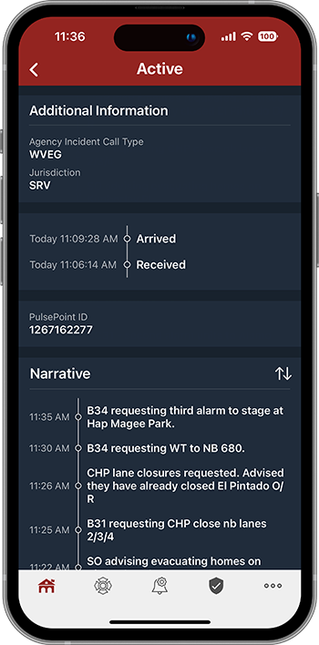
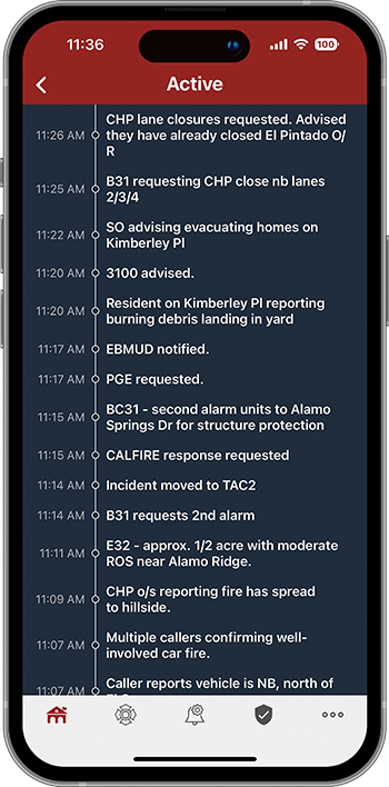
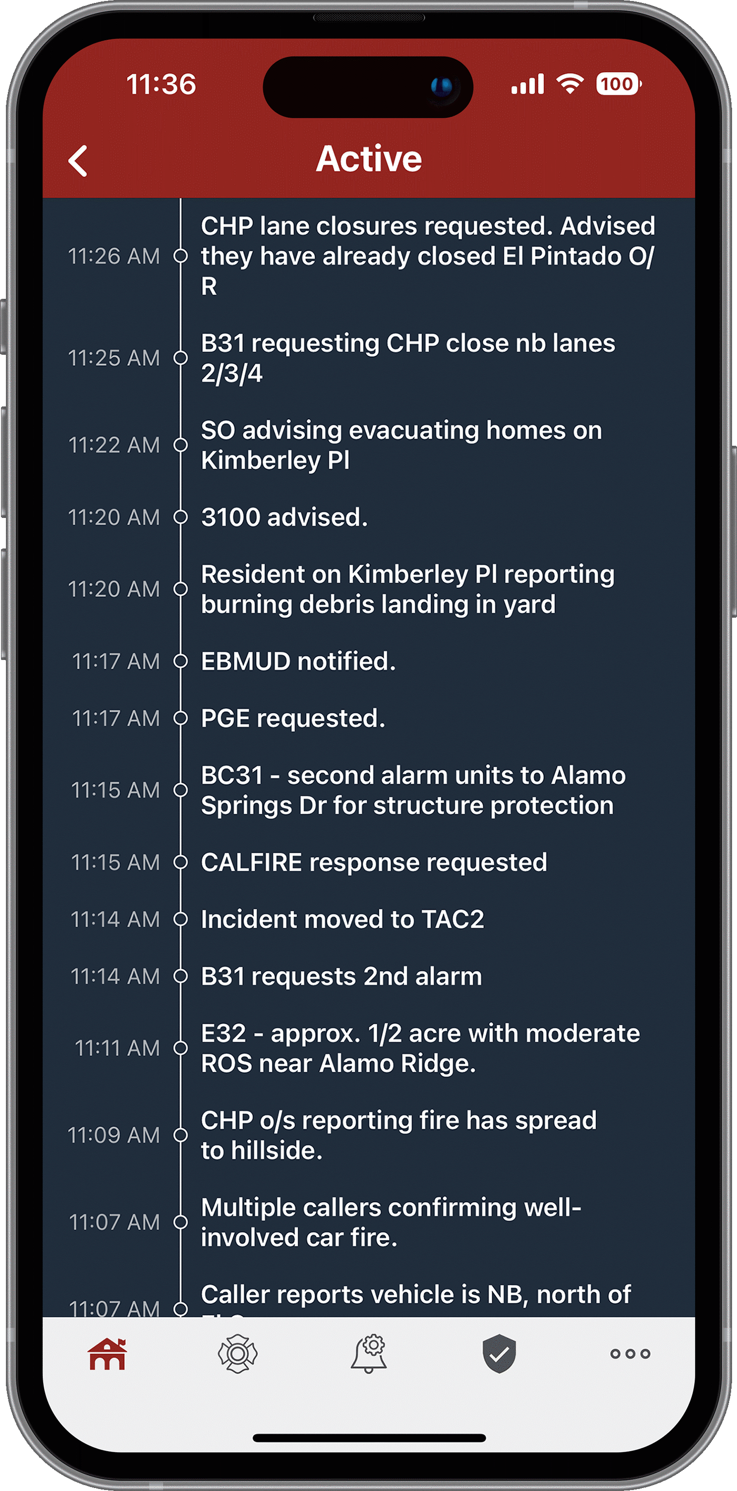
Incident narrative
INSIGHT THAT ONLY CAD NOTES CAN PROVIDE
The event chronology provides valuable, real-time information that is often unavailable to responding personnel. Incident narratives provide unique insight into a progressing event that, when shared, can help provide a common operating picture and improve situational awareness.
The narrative timeline appears on the incident detail page. It includes all entries from event creation through final disposition and is continually updated in real time.
| Public | Registered | Professional |
| No | No | Yes |


Recent Location History
A LOOK BACK IN TIME
Immediate access to location history can improve patient care, provide important crew safety information, and expand situational awareness in a wide variety of scenarios. When different shifts, and different units, respond to the same locations at different times, quickly accessing patient and premise history has been a challenge—until now.
Recent incidents for the exact response location (including suite, apartment number, etc.) are displayed below the current narrative. Tap any of these recent events to view the complete detail page from the prior incident.
| Public | Registered | Professional |
| No | No | Yes |


NEAR Registry
All NEAR Registry users can view AED and emergency resource locations (bleeding control kits, epinephrine, and naloxone). These users can also recommend new locations and provide feedback on existing AEDs and resources in the registry
INCREASED REGISTRY OVERSIGHT AND QUALITY
Professional Responders are granted additional rights to approve community-recommended AEDs and resources, and to managing basic aspects of the registry.
| Public | Registered | Professional |
| Recommend/comment | Recommend/comment | Approve/manage |